The Kiso Valley is the part of Japan that most convincingly drops you into the Edo period. It carries the old Nakasendo, the highway that linked Edo and Kyoto, through the mountains where Nagano meets Gifu, leaving behind a chain of beautifully preserved post towns. Two of them stand out: Tsumago-juku, which has no power lines and no cars and was one of Japan's first designated preservation districts in 1976, and Magome-juku, a stone-paved street climbing a hillside. And what links them is the single most iconic surviving stretch of the Nakasendo: an 8 km walk over Magome Pass that takes a relaxed 2.5–3 hours, with a baggage-forwarding service (around ¥1,000) that lets you walk hands-free. This guide covers transport, what each town offers, how to walk the trail, the luggage service, lodging, and a Narai-juku add-on. To pair it with Hida-Takayama, see our Takayama guide.
- Tsumago vs Magome: Tsumago is flat, power-line-free, and undiluted; Magome is a lively stone slope with views to Mt. Ena
- The classic move is walking the old road: about 8 km over Magome Pass, 2.5–3 hours, nicknamed the Samurai Trail
- Baggage forwarding ¥1,000: drop 8:30–11:30 a.m., collect 1:00–5:00 p.m., daily Mar 20–Nov 30
- Access: Nagoya → Nakatsugawa on the Shinano express (~50 min), then bus to Magome; Tsumago is at Nagiso Station
- Stay a night: dawn and dusk in an empty Tsumago street is the Kiso Valley at its best
📖 Contents
Why visit the Kiso Valley
Honestly, Japan has no shortage of "old streets," but Tsumago and Magome are special because they are not a shopping arcade dressed up as history — they are a whole length of old road that time was allowed to keep. In the Edo period the Nakasendo was one of the two great highways alongside the Tokaido, with 69 post towns (juku) spaced along it where travelers rested. The Kiso section was the most rugged, and its post towns the most characterful. Most of those towns have since modernized, but Tsumago and Magome, two neighboring post towns, along with the trail over Magome Pass between them, were deliberately preserved whole — which lets you do something rare in Japan: walk, on your own two feet, from one Edo post town to the next.
The value of the Kiso Valley is not in any single sight; it is that the route itself is the experience. The scale is right: a day covers the highlights, and it is worth an overnight for the empty street at dawn and dusk. If you have already done Kyoto and Osaka and want something quiet, weighted with history, and without a serious climb, the Kiso Valley fits. Per official sources, it links easily with Hida-Takayama and Narai-juku into a "Chubu old-road line." The advice is direct: do not treat it as an old street you glance at on the way past — give it a full day, ideally a night, because the best of this road hides in the hours with no tourists.
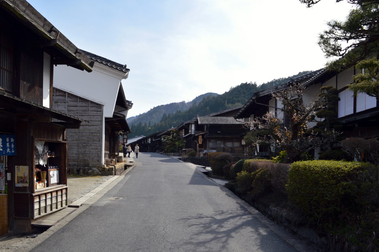
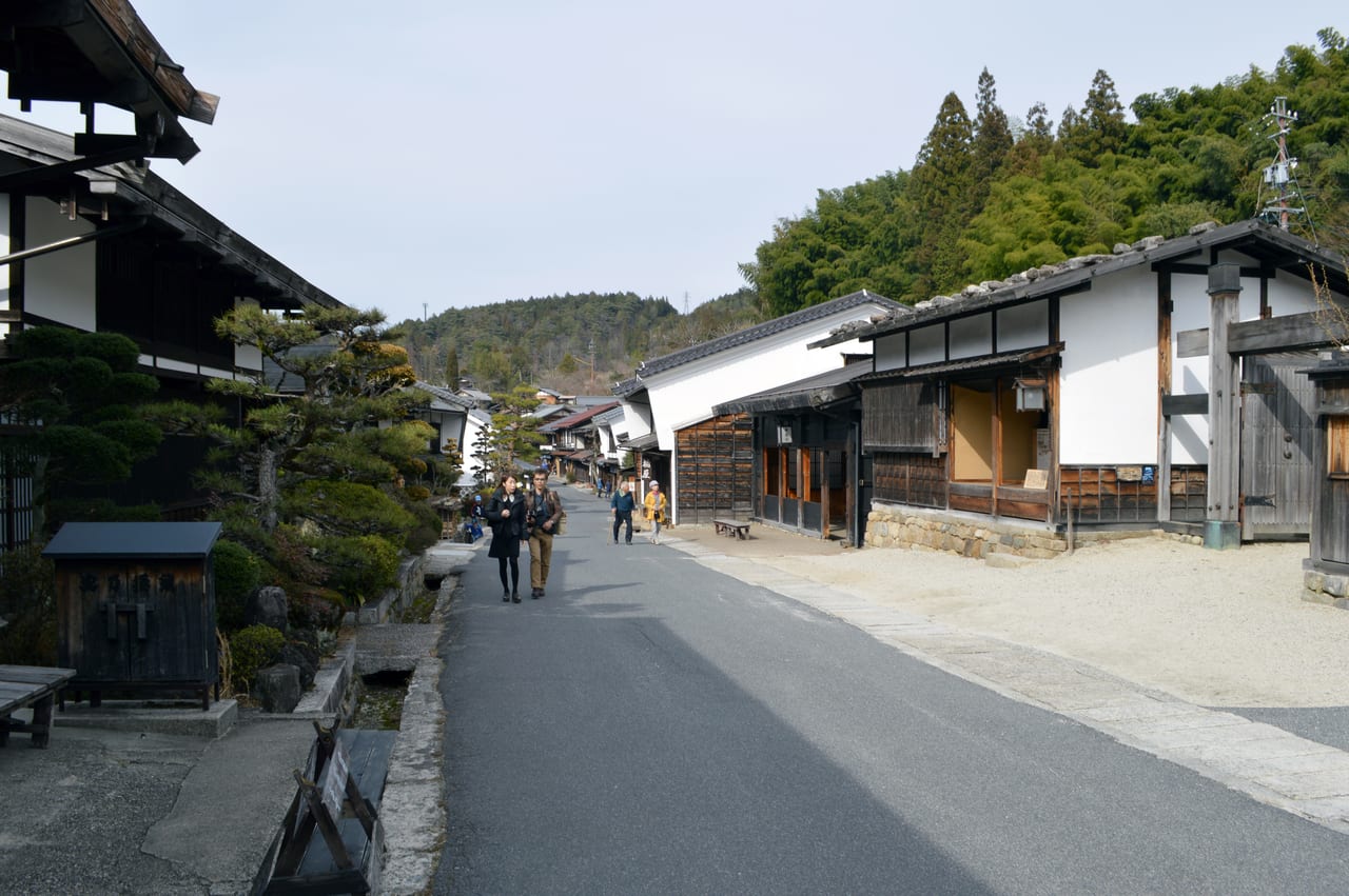
Tsumago-juku: the power-line-free Edo street
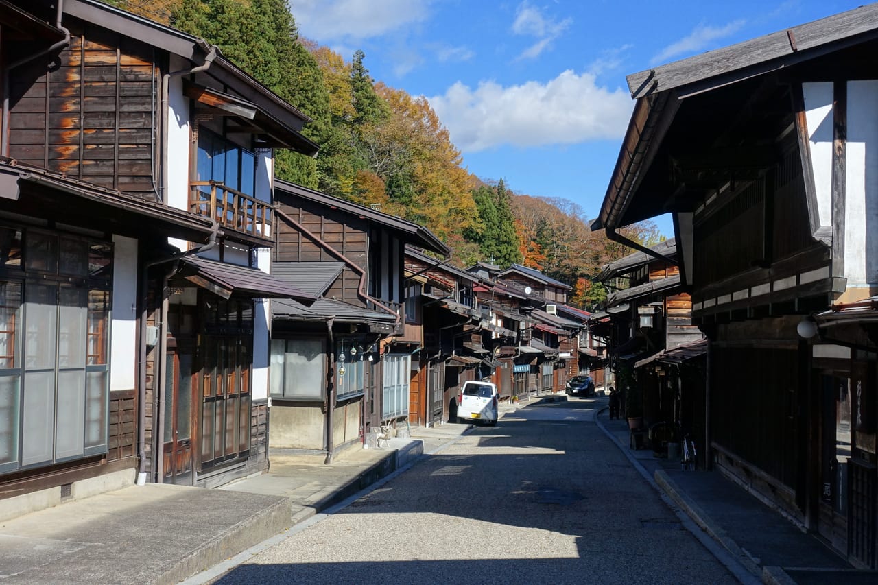
Tsumago-juku sits in Nagiso, Nagano, and was the 42nd post town on the Nakasendo. According to official sources, it became one of Japan's first designated "Important Preservation Districts for Groups of Traditional Buildings" in 1976 — and that "first" matters. In an era when old streets across the country were tearing themselves down to modernize, Tsumago's residents agreed not to sell, rent, or demolish their old houses, treating the whole street as a living museum. That resolve is exactly why it still looks the way it does.
Walking in, the first thing you notice is how clean the view is — no power lines, no air-conditioning units bolted to facades, no neon signage, and no cars by day. Wooden hatago (Edo-era inns), latticed windows, and udatsu firewalls line up one after another, with almost nothing modern in sight. Highlights include the restored Waki-honjin Okuya (a high-grade lodging once used by samurai and feudal lords, now a museum), the Tsumago-juku Honjin, and the quiet lane at the end of the street that feeds into the trail. Tsumago's whole character is stillness; it does not hawk and bustle like Magome — it slows you down until you can hear your own footsteps. Per traveler reports, it is best at dawn and dusk: once the tour buses leave, the street belongs almost entirely to overnight guests, a Tsumago the daytime crowds never see.
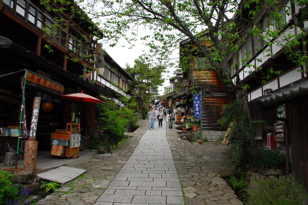
Magome-juku: the stone-paved hill town
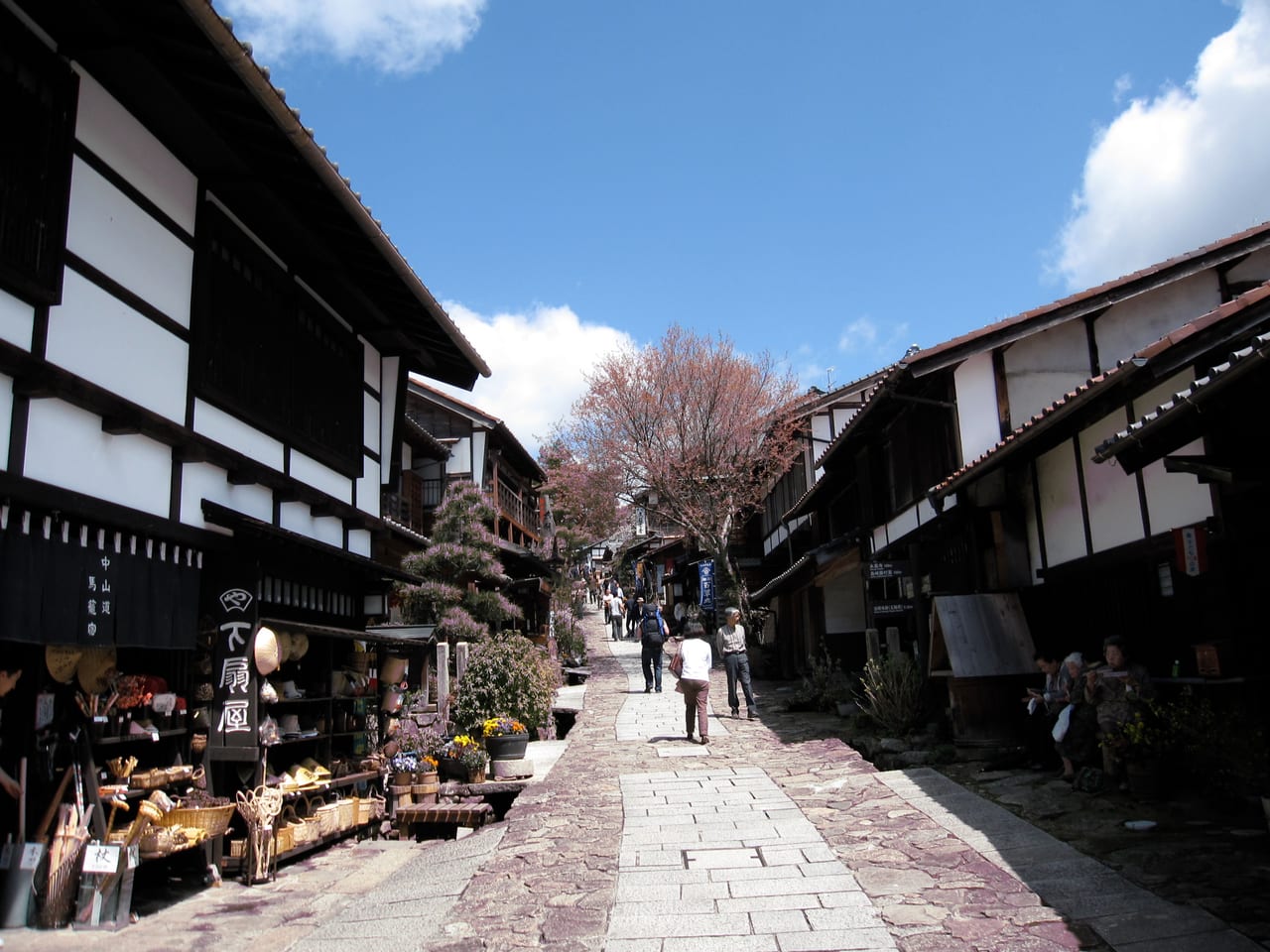
Magome-juku is in Nakatsugawa, Gifu — the 43rd post town, Tsumago's neighbor and the other end of the trail. The biggest contrast with Tsumago is the terrain: Magome is a stone-paved street that climbs a hillside, rising from the lower gate to the upper gate past stone retaining walls, water wheels, teahouses, and souvenir shops. The higher you go, the wider the view, and on a clear day you can look out toward Mt. Ena and the Kiso valley. It is livelier and more commercial than Tsumago, but that undulating stone street against a backdrop of mountains is very photogenic.
Magome's other identity is as the hometown of the novelist Shimazaki Toson — his novel Before the Dawn is set along the Nakasendo and Magome, and the Toson Memorial Museum, built on the site of his family's honjin, is the town's cultural anchor. Along the street, try the Kiso specialty gohei-mochi (flattened rice cakes brushed with miso or walnut sauce and grilled), chestnut sweets (the area is known for chestnuts), and soba. Because Magome is higher and more open, many people start there and walk down — "in at Magome, out at Tsumago" — browsing and eating in Magome first, then following the old road downhill to Tsumago, which also distributes the climb more sensibly.
Walking the Magome–Tsumago trail
This is the soul of the Kiso Valley, and the thing this guide most wants to push you toward. The Nakasendo trail between Tsumago and Magome runs about 8 km over Magome Pass (around 790 m), taking 2.5–3 hours at a relaxed pace. Foreign visitors nickname it the "Samurai Trail," but do not let the name intimidate you — it is a hike, not a mountain climb. The surface mixes stone paving, dirt path, and some paved sections, it is clearly signposted, and even families manage it.
Which direction? Most people choose Magome → Tsumago, because Magome sits higher: you climb a stretch to Magome Pass first, then it is almost all downhill to Tsumago, making the second half much easier. The reverse, Tsumago → Magome, puts the climb in the back half and tires you more — though it makes sense if you are staying in Tsumago and want to end the day shopping and eating in Magome. Highlights along the way include the Magome Pass marker and teahouse at the top, the free rest teahouses partway, and a pair of side-by-side waterfalls, the Otaki and Metaki (male and female falls) — according to official sources, a popular little stop on the trail, said to feature in samurai-novel lore, and worth the short detour.
You do not need elaborate gear, but get a few things right: wear comfortable, grippy shoes (stone and dirt sections get slick in rain), carry water, bring sun protection in summer, and check your return bus or train times. Phone signal comes and goes along the trail, so save offline maps and timetables in advance. The hills have bears, and bells are mounted along the path to ring as you pass — per official guidance, give one a ring to make noise; it is the local custom, so just do it. On the whole it is a high-reward, low-barrier trail, and finishing it makes clear why people say the Kiso Valley is about walking, not just looking.
Baggage forwarding & trail logistics
Many people get stuck on one question: "I have a suitcase — surely I am not hauling it over a mountain pass?" This is where the Kiso Valley shines. The tourist information centers in both Tsumago and Magome run a baggage forwarding service, around ¥1,000 per item per traveler reports. The process is simple: drop bags at the center in your starting town between 8:30 and 11:30 a.m., then collect them at the other town's center between 1:00 and 5:00 p.m. the same day. In Magome the drop-off is beside Magome Chaya and in front of the Toson Memorial Museum; in Tsumago it is in the village center near the post office. According to official information, the service runs daily from March 20 to November 30.
A few practical notes:
- Mind the morning window: drop-off closes at 11:30, so start early — forward your bags first, then set off, and you walk the 8 km hands-free and collect on the far side in the afternoon.
- No service in winter (December to mid-March): to walk the trail then, send big bags ahead by takkyubin (Yamato and others) directly to your next hotel, or simply stroll the post towns instead of hauling luggage over the pass.
- Staying overnight is even simpler: if you sleep in Tsumago or Magome tonight, leave your bags at the inn and walk the trail light — no forwarding needed.
- Bus fallback: if you tire or the weather turns, local buses run between Tsumago (Nagiso) and Magome, so you do not have to push through. Per official information, services are limited, so check the timetable first.
Beyond: Narai-juku & Kiso scenery
If you have the time and want more post towns, Narai-juku at the northern end of the Kiso valley is well worth adding. According to official sources, Narai was the 34th post town on the Nakasendo, sits at about 940 m, and is the highest post town in the Kiso — back then it lay at the foot of the steep Torii Pass, where travelers had to rest and regroup, so it prospered to the point of being called "Narai of a Thousand Houses." It is likewise an Important Preservation District and one of the longest surviving post-town streets in Japan, about 1 km of continuous wooden townhouses — longer than Tsumago or Magome, and usually less crowded. Narai is right beside Narai Station on the JR Chuo Line, so heading north from the Tsumago/Magome side links it in easily, making a neat "south: Tsumago and Magome + north: Narai" three-post-town day.
Two scenic spots are often mentioned with the valley. Nezame-no-Toko is a beauty spot where the rushing Kiso River has carved enormous granite blocks; the white rock against the emerald water has drawn poets and ukiyo-e artists for centuries, per official sources, and it sits near Agematsu Station. The other is the Torii Pass old road behind Narai-juku, from which you can see Mt. Ontake on a clear day. You do not have to do all of these, but if you are the "traverse the whole Kiso valley" type, pick one or two on the way to upgrade your trip from "two post towns" to "the whole Kiso road."
Transport & lodging
Getting in runs on the JR Chuo Line limited express "Shinano." Per official timetables: Nagoya → Nakatsugawa is about 50 minutes, then a Kitaena Kotsu local bus of about 30 minutes to Magome (around ¥570 one way, not covered by the JR Pass). For Tsumago, ride to Nagiso Station — a few Shinano expresses stop there, but most require a transfer to a local train at Nakatsugawa; from Nagiso, a bus (around ¥300) or taxi (around ¥2,000) reaches Tsumago. Coming from Tokyo, route via the Hokuriku or Tokaido Shinkansen onto the Chuo Line, or simply in and out of Nagoya, which is the cleanest. The nationwide JR Pass covers the JR express legs to Nakatsugawa / Nagiso, but the final local bus is not included — pay cash on board. Check whether the pass pays off using our JR Pass guide. The Kiso Valley also flows naturally onward to Hida-Takayama — see our Takayama guide for connecting the trip.
Buses and timing are the variable that makes or breaks this trip. Per official 2026 information, the local buses from Nagiso Station to Tsumago and Magome run on different patterns (some daily, some added only during Golden Week and the summer, some suspended around New Year), the frequency is not high, and seats cannot be reserved — so check your outbound and return bus and train times before you leave, rather than discovering on arrival that the next one is an hour away. Driving is an option too (both towns have parking), but with a car you cannot "walk the trail one-way" (you have to return to wherever you parked), so most travelers stick with public transport plus the baggage service, which flows best.
For lodging, the strongest choice is to stay inside the Tsumago or Magome post town itself. Both have Edo-style hatago and old-farmhouse inns with few rooms, so book early in peak season (autumn foliage, long weekends). The big payoff, as noted, is seeing the empty approach at dawn and the street after the day-trippers have gone — scenes a day trip misses entirely. Dinner is usually Kiso country cooking — mountain vegetables, river trout, soba, gohei-mochi. If you prefer a more modern hotel, base in Nakatsugawa or near Nagiso Station and commute into the towns each day; but if you want the atmosphere, staying inside the post town is the right answer. Kiso lodging is limited, so reserve well ahead.
One-day & two-day plans
Here is the same content shaped into two routes that walk well:
- One day (day trip from Nagoya): morning Shinano express from Nagoya to Nakatsugawa (~50 min) → bus to Magome, explore the stone slope, Toson Memorial Museum, and gohei-mochi → forward your bags at the Magome center before 11:30 (¥1,000) → walk the trail over Magome Pass to Tsumago (~8 km, 2.5–3 hours, with the Otaki/Metaki waterfalls on the way) → collect bags at the Tsumago center in the afternoon, explore Waki-honjin Okuya and the old street → train back to Nagoya from Nagiso.
- Two days (an overnight is best): Day 1 as above, but skip the evening rush and stay at a hatago in Tsumago or Magome, dining on Kiso country cooking and enjoying the empty street at dusk and the next dawn. Day 2, head north to add Narai-juku (Chuo Line to Narai Station), walk one of the longest post-town streets in Japan, and, time permitting, see Nezame-no-Toko on the way before returning to Nagoya or continuing to Takayama.
If you want an easy stroll without the trail, you can also do "browse Magome → bus to Tsumago → browse Tsumago," shuttling by road and skipping the pass — but you lose the Kiso Valley's best experience, the walk over the mountains. North of here the road continues to Narai and Matsumoto; west it connects to Hida-Takayama and Shirakawa-go, making this a fine launch point for a Chubu old-road and mountain route. For pre-trip weather and packing, see our Japan packing & weather guide, and for overall Japan itinerary planning, the approach in our Tokyo 5-day itinerary is a useful template.
FAQ
Frequently Asked Questions
- Q1:Tsumago or Magome — which should I pick, and is one enough?
- Both are worth it, but they have different characters. Tsumago-juku is a flat, quiet street with no power lines and no cars — the most thoroughly preserved of the two. Magome-juku is a sloping, stone-paved street climbing a hillside, livelier, with open views toward Mt. Ena. According to official sources, the stretch between them is the most iconic surviving section of the Nakasendo. If you can only do one: pick Magome for photos, dango, and souvenir browsing; pick Tsumago for a silent, undiluted Edo street. But the strongest play is to do both and link them on foot — the 8 km walk over the pass is the main event, not a side dish.
- Q2:How long is the Magome–Tsumago walk, and how hard is it?
- According to official and traveler sources, the walk between Magome-juku and Tsumago-juku is about 8 km over Magome Pass (around 790 m elevation), taking roughly 2.5–3 hours at a relaxed pace. Most people walk Magome → Tsumago, because Magome sits higher: you climb to the pass first, then it is mostly downhill to Tsumago, which is easier on the legs. The path mixes stone paving, dirt, and some paved sections, is clearly signposted, and is nicknamed the "Samurai Trail" by foreign visitors. It is a hike, not a mountain climb — fine for families. Along the way you pass the Otaki and Metaki waterfalls, rest teahouses, and terraced hamlets. Bears live in these hills, so bells are mounted along the trail to ring as you pass — per official guidance, just ring them.
- Q3:What do I do with my luggage during the walk? Is there a forwarding service?
- Yes, and it is excellent. The tourist information centers in both Tsumago and Magome run a baggage forwarding service, around ¥1,000 per item per traveler reports. You drop bags at the center in your starting town between 8:30 and 11:30 a.m., then collect them at the other town's center between 1:00 and 5:00 p.m. the same day. According to official information, the service runs daily from March 20 to November 30 (stopped in winter). In Magome the drop-off is beside Magome Chaya and in front of the Toson Memorial Museum; in Tsumago it is in the village center near the post office. This lets you walk the trail hands-free instead of hauling a suitcase over the pass. When the service is off in winter, send big bags by takkyubin (Yamato) ahead to your next hotel.
- Q4:How do I get to the Kiso Valley from Nagoya? Does the JR Pass work?
- The main route is the JR Chuo Line limited express "Shinano": per official timetables, Nagoya → Nakatsugawa is about 50 minutes, then a bus of about 30 minutes (around ¥570 one way, not covered by the JR Pass) to Magome. For Tsumago, get off at Nagiso Station — a few Shinano expresses stop there, but most require a transfer to a local train at Nakatsugawa; from Nagiso, a bus (around ¥300) or taxi (around ¥2,000) reaches Tsumago. The nationwide JR Pass covers the JR express legs to Nakatsugawa / Nagiso, but the final local bus to the post towns is not included — pay cash on board. Price the nationwide pass against your route first with the break-even math in our JR Pass guide.
- Q5:Can I do the Kiso Valley in a day, or should I stay overnight?
- If you just walk Magome → Tsumago and browse each town, a day trip from Nagoya is doable — budget a full day: morning in Magome, the trail around midday, Tsumago in the afternoon, then a train back. But the real magic of the Kiso Valley is dawn and dusk — once the day-trippers leave, Tsumago's street is nearly empty, and that is when it is most beautiful, which only an overnight gives you. Both towns have Edo-style inns (hatago, old farmhouses), and dinners lean on Kiso country cooking — mountain vegetables, river trout, gohei-mochi. Stay a night to go deep; a day trip is fine for the highlights. It also pairs naturally with Takayama and Narai-juku as a "Nakasendo + Hida" old-road route.
- Q6:What month is best for the Kiso Valley? Can I go in winter?
- According to official sources and traveler reports, the sweet spots are spring (fresh green, April–May) and autumn (foliage, late October to mid-November), when the forests and terraces along the trail are at their most colorful and the temperature is pleasant — peak photo season. Summer is cooler in the Kiso valley than the lowlands, but the trail has some climbing, so carry water. Winter (Dec–Feb) gives the post towns atmospheric snow and the fewest crowds, but the trail can be icy, the baggage service stops, and some teahouses close — plan conservatively. In short: first visit and want to walk the trail, choose spring or autumn; want snow and silence and are happy to just stroll the towns, winter has its own charm. See our Japan packing & weather guide before you go.
Related reading:
Hida-Takayama Guide 2027: Old Town, Jinya, Hida Beef & Festival
The little Kyoto of Hida — the Sanmachi old streets, Japan's only surviving jinya, the morning market, Hida beef and the Takayama Festival.
Karuizawa Guide 2026: Kumoba Pond, Shiraito Falls & Outlets
Tokyo's easiest highland escape, 60 minutes by Hokuriku Shinkansen — Kumoba Pond reflections, Shiraito Falls, the Prince outlet, Hoshino-area churches and Harunire Terrace.
Tokyo 5-day itinerary 2026
A clear 5-day plan: Shinjuku base, two zones per day, honest budget.